Sheila and I went for a walk in Lexington MA Wednesday May 5th, 2021. There are a group of loop trails which connect parcels of open space with road walking along mostly quiet neighbourhood streets. Today we walked Route M If you walk them all you can maybe get a certificate.
We parked at the trailhead at the back of the office park at 45 hayden street. The trailhead is easy to find just east of the parking garage at the back of the campus. There are several parking spots reserved for it.
 |
| Sign on Hayden Ave. The trailhead is at the back near the parking garage |
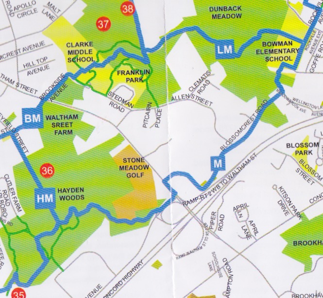
Here is a mp of route M, we did the loop counterclockwise starting in the lower left corner of the map.
From the trailhead in the parking lot it's just a short walk to get to route M.
 |
| Route M map |
We started off in a light drizzle around 10:40 but that quickly stopped. The map says route M is 3.3 miles. We missed a turn at Bowman Elementary School and started heading up route L. We had not gone too far when we figured out our problem and backtracked. We had to walk through the school playground which was in use to get to the spot where the trail enters Dunback Meadow. We finished up around 12:20.
Here is a mailbox we saw along the way that I liked.
 |
| Mailbox we walked past |
Boardwalk in Hayden woods
 |
| Boardwalk Hayden woods |
Signpost where several trail converge, pay attention as these can be confusing. The arrows each have a letter. Follow the arrow with your letter. Simple?
 |
Across Lexington Signpost at junction of Trails H, M, and B
|
Not too surprising ( since it is Lexington and I was with Sheila rather then Larry ) there was no trail junk seen so no old junk picture of the day.