
Friday, May 28, 2021
Bay Circuit trail finished
Thursday, May 6, 2021
Berlin MA to the Clinton Tunnel on the Mass Central Rail Trail and back
 |
| Map of the MCRT from Berlin to and including the Clinton tunnel. screenshot of the map on the masscentralrailtrail.org site |
We have been walking the MCRT in segments from Belmont MA westward. Our first segment was Belmont to Waltham, then Waltham to Sudbury, then Sudbury to Holden, Holden to Berlin and now todays walk, Berlin up to and including the Clinton train tunnel and back.
This section is all marked in blue on the map. That's supposed to mean that it's unofficial, bikeable and walkable. For the most part this is true. In a few places on this segment people have extended their lawn across the right of way so you have to cross their lawn. In other places buildings have been built on top of where the tracks once ran and we were forced to walk on the street. In addition in some places the brush on the trail was so thick that you would be pushing your bicycle and lifting it over downed trees.
 |
| Trail where we started in Berlin |
 |
| Trail after the tracks have been taken up |
 |
| West end of the tunnel. See the light at the end? |
Wednesday, May 5, 2021
Route M from Walks in Lexington
Sheila and I went for a walk in Lexington MA Wednesday May 5th, 2021. There are a group of loop trails which connect parcels of open space with road walking along mostly quiet neighbourhood streets. Today we walked Route M If you walk them all you can maybe get a certificate.
We parked at the trailhead at the back of the office park at 45 hayden street. The trailhead is easy to find just east of the parking garage at the back of the campus. There are several parking spots reserved for it.
 |
| Sign on Hayden Ave. The trailhead is at the back near the parking garage |
From the trailhead in the parking lot it's just a short walk to get to route M.
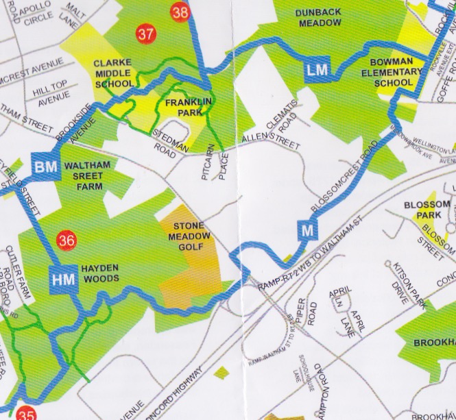 |
| Route M map |
We started off in a light drizzle around 10:40 but that quickly stopped. The map says route M is 3.3 miles. We missed a turn at Bowman Elementary School and started heading up route L. We had not gone too far when we figured out our problem and backtracked. We had to walk through the school playground which was in use to get to the spot where the trail enters Dunback Meadow. We finished up around 12:20.
Here is a mailbox we saw along the way that I liked.
Boardwalk in Hayden woods
Signpost where several trail converge, pay attention as these can be confusing. The arrows each have a letter. Follow the arrow with your letter. Simple?
Not too surprising ( since it is Lexington and I was with Sheila rather then Larry ) there was no trail junk seen so no old junk picture of the day.
 |
| Mailbox we walked past |
 |
| Boardwalk Hayden woods |
 |
| Across Lexington Signpost at junction of Trails H, M, and B |
Monday, January 25, 2021
G to H gap BCT Map 13
We have been hiking the BCT in segments for some time now. We are well south of Boston having completed 200 or so miles of trail. We are on Map 13 and plan to finish in 3 more hikes.
 |
| Screenshot of the BCT map showing the gap |
There is a gap in the BCT between points G and points H on Map 13. We recently hiked this section, when we came to the last BCT marker we could find we turned left and followed a thin red line trail shown on the BCT map headed out to route 27. You might notice that the trail does not connect with the road. We then followed route 27 to Crooker Place and then to the parking at H on the map.
 |
| Wet trail |
I can't recommend this route. The trail was quite wet, required some bushwacking, ended up on a private property construction site alongside some old warehouses, and took us a mile or more out of our way.
We learn a better route
Once we got to parking lot H we met a woman walking her dog who told us you could follow the trails all the way to Elm street from there. She knew the BCT was "back there somewhere". Thus inspired we headed back down the trail a bit and in a few minutes without any problem we came to the end of the trail where an hour or so earlier we had turned left.
How you could cross the gap to H
Much of the trail from G to H runs on or alongside a swath cut through the pine forest. If once you reach the gap instead of turning left you instead stay on the trail, cross a swampy bit on some branches which have been thrown down you will find the trail soon rises to higher ground and turns to the right. A bit farther on it turns to the left and rejoins the swath cut through the pine forest. A little farther on the trail turns left from the swath and comes out at parking area H.
 |
| View of the gap from google maps. The cleared swath is quite visible, the route leaves the cleared swath to cross a swampy bit and then rejoins the swath. The gap starts just before you cross. |
About the gap
Looking at the Hanson open space map the gap is on land is marked "Privately owned open space" The parking lot and the openspace kiosk at H are on a bit of land marked "town owned land".
My guess is the BCT has not been able to get permission to run the trail across this property and for that reason it's not blazed and not on the map. It would great if the route could be shown on the map as a thin red line as they do other trails in this area which are adjacent to the BCT and or provide some hint in the trail description on how to cross this gap.
Enjoy the trail!
Subscribe to:
Comments (Atom)