
Friday, May 28, 2021
Bay Circuit trail finished
Thursday, May 6, 2021
Berlin MA to the Clinton Tunnel on the Mass Central Rail Trail and back
 |
| Map of the MCRT from Berlin to and including the Clinton tunnel. screenshot of the map on the masscentralrailtrail.org site |
We have been walking the MCRT in segments from Belmont MA westward. Our first segment was Belmont to Waltham, then Waltham to Sudbury, then Sudbury to Holden, Holden to Berlin and now todays walk, Berlin up to and including the Clinton train tunnel and back.
This section is all marked in blue on the map. That's supposed to mean that it's unofficial, bikeable and walkable. For the most part this is true. In a few places on this segment people have extended their lawn across the right of way so you have to cross their lawn. In other places buildings have been built on top of where the tracks once ran and we were forced to walk on the street. In addition in some places the brush on the trail was so thick that you would be pushing your bicycle and lifting it over downed trees.
 |
| Trail where we started in Berlin |
 |
| Trail after the tracks have been taken up |
 |
| West end of the tunnel. See the light at the end? |
Wednesday, May 5, 2021
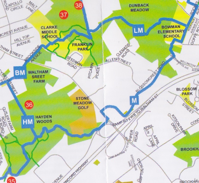
Route M from Walks in Lexington
Sheila and I went for a walk in Lexington MA Wednesday May 5th, 2021. There are a group of loop trails which connect parcels of open space with road walking along mostly quiet neighbourhood streets. Today we walked Route M If you walk them all you can maybe get a certificate.
We parked at the trailhead at the back of the office park at 45 hayden street. The trailhead is easy to find just east of the parking garage at the back of the campus. There are several parking spots reserved for it.
 |
| Sign on Hayden Ave. The trailhead is at the back near the parking garage |
From the trailhead in the parking lot it's just a short walk to get to route M.
 |
| Route M map |
We started off in a light drizzle around 10:40 but that quickly stopped. The map says route M is 3.3 miles. We missed a turn at Bowman Elementary School and started heading up route L. We had not gone too far when we figured out our problem and backtracked. We had to walk through the school playground which was in use to get to the spot where the trail enters Dunback Meadow. We finished up around 12:20.
Here is a mailbox we saw along the way that I liked.
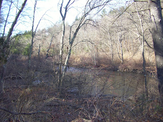
Boardwalk in Hayden woods
Signpost where several trail converge, pay attention as these can be confusing. The arrows each have a letter. Follow the arrow with your letter. Simple?
Not too surprising ( since it is Lexington and I was with Sheila rather then Larry ) there was no trail junk seen so no old junk picture of the day.
 |
| Mailbox we walked past |
 |
| Boardwalk Hayden woods |
 |
| Across Lexington Signpost at junction of Trails H, M, and B |
Monday, January 25, 2021
G to H gap BCT Map 13
We have been hiking the BCT in segments for some time now. We are well south of Boston having completed 200 or so miles of trail. We are on Map 13 and plan to finish in 3 more hikes.
 |
| Screenshot of the BCT map showing the gap |
There is a gap in the BCT between points G and points H on Map 13. We recently hiked this section, when we came to the last BCT marker we could find we turned left and followed a thin red line trail shown on the BCT map headed out to route 27. You might notice that the trail does not connect with the road. We then followed route 27 to Crooker Place and then to the parking at H on the map.
 |
| Wet trail |
I can't recommend this route. The trail was quite wet, required some bushwacking, ended up on a private property construction site alongside some old warehouses, and took us a mile or more out of our way.
We learn a better route
Once we got to parking lot H we met a woman walking her dog who told us you could follow the trails all the way to Elm street from there. She knew the BCT was "back there somewhere". Thus inspired we headed back down the trail a bit and in a few minutes without any problem we came to the end of the trail where an hour or so earlier we had turned left.
How you could cross the gap to H
Much of the trail from G to H runs on or alongside a swath cut through the pine forest. If once you reach the gap instead of turning left you instead stay on the trail, cross a swampy bit on some branches which have been thrown down you will find the trail soon rises to higher ground and turns to the right. A bit farther on it turns to the left and rejoins the swath cut through the pine forest. A little farther on the trail turns left from the swath and comes out at parking area H.
 |
| View of the gap from google maps. The cleared swath is quite visible, the route leaves the cleared swath to cross a swampy bit and then rejoins the swath. The gap starts just before you cross. |
About the gap
Looking at the Hanson open space map the gap is on land is marked "Privately owned open space" The parking lot and the openspace kiosk at H are on a bit of land marked "town owned land".
My guess is the BCT has not been able to get permission to run the trail across this property and for that reason it's not blazed and not on the map. It would great if the route could be shown on the map as a thin red line as they do other trails in this area which are adjacent to the BCT and or provide some hint in the trail description on how to cross this gap.
Enjoy the trail!
Saturday, December 7, 2013
BCT - "You boys going to get somewhere, or just going?"
Saturday December 7, 2013
From where the power lines cross River Road in Andover to downtown Lowell
Started hiking around 12:30 PM finished around 3PM.
Miles hiked today 6 total, .2 on the side trail and 5.8 on the BCT
After todays hike total BCT miles completed: 25.1 out of a total of maybe 180.
Weather sunny and 30's
Hikers Ted and Larry
We dropped the downstream car in a parking garage in Lowell and drove the other car to where the power lines crossed River Road in Andover. There was supposed to be a side trail leading .2 miles down to the BCT but we never found it. According to the map the BCT ran along the river so we just bushwhacked our way downhill under the power lines till we found the BCT.
After a couple of miles hiking through the woods we came to a golf course which runs from River street all the way down to the Merrimack. It would seem the trail could cross the golf course alongside the river but I guess it can't. The trails climbs up and back to River road. The trail then followed the road. Once clear of the golfers the trail then cut through a cemetery and back to the river.

Lowell was the home of Jack Kerouac. This quote from "On The Road" seems to fit.
“You boys going to get somewhere, or just going?”― Jack Kerouac, On the Road, Chapter 3
From where the power lines cross River Road in Andover to downtown Lowell
Started hiking around 12:30 PM finished around 3PM.
Miles hiked today 6 total, .2 on the side trail and 5.8 on the BCT
After todays hike total BCT miles completed: 25.1 out of a total of maybe 180.
Weather sunny and 30's
Hikers Ted and Larry
 |
| Map of todays hike from the "P" on the right to the "P" on the left |
We dropped the downstream car in a parking garage in Lowell and drove the other car to where the power lines crossed River Road in Andover. There was supposed to be a side trail leading .2 miles down to the BCT but we never found it. According to the map the BCT ran along the river so we just bushwhacked our way downhill under the power lines till we found the BCT.
 |
| Trail along the river |
 |
| Trail Bridge |
 |
| Trail crossing land owned by the Andover Village Improvement Society |
After a couple of miles hiking through the woods we came to a golf course which runs from River street all the way down to the Merrimack. It would seem the trail could cross the golf course alongside the river but I guess it can't. The trails climbs up and back to River road. The trail then followed the road. Once clear of the golfers the trail then cut through a cemetery and back to the river.
 |
| RT 38 bridge where the trail leaves the river |
Much of the rest of the todays hike runs along the river on top of a underground sewer route. The ground is paved with large not quite flat stones making for tricky walking. The guide makes this note about this section:
"This stretch has not
been uniformly maintained and some abutters
have encroached on the right of way with
gardens, patios, and building debris. It is,
however, passable and public" - Bay Circuit Trail Guide
 |
| Rough walking surface and sign of Beaver activity |
When we got to Lowell we followed the road to the Lowell Memorial Auditorium.
 |
| Lowell Memorial Auditorium |
In Lowell we crossed this bridge noting that today was 7 December 2013

Following the canal walk along the Pawtucket Canal back to the parking garage where the car was parked.
 |
| One end of a restored set of locks |
Old Machinery Picture of the Day: We were almost done and had not spotted anything. I took a picture of this discarded V8 engine just in case we didn't find anything better. I'm not really sure it qualifies as old.
 |
| V8 |
But right at the end of our hike we were saved by this piece of field artillery outside the Lowell Memorial Auditorium. This picture is our "Old Machinery Picture of the Day".
 |
| Old Machinery Picture of the Day |
Lowell was the home of Jack Kerouac. This quote from "On The Road" seems to fit.
“You boys going to get somewhere, or just going?”― Jack Kerouac, On the Road, Chapter 3
Sunday, November 24, 2013
BCT - Strawberry Hill Road forever
Sunday November 24, 2013
Wheeler lane Acton to Old North Bridge, Concord, 8.5 miles
Wheeler lane Acton to Old North Bridge, Concord, 8.5 miles
Started hiking around 10AM finished around 2PM. Too cold to stop for more than a minute.
Hikers Ted and Larry
Most of this segments photos are from Larry.
Most of this segments photos are from Larry.
Weather was sunny in the low to mid 20's, 20 MPH winds with gusts to 40 MPH
After todays hike total BCT miles completed: 19.3 out of a total of 180. ( I know I was saying it was 250 miles total but if you skip the proposed sections and the alternate sections then 180 miles total seems to be the a better estimate of the real distance. Anyway this way we are more than 10% done. )
After todays hike total BCT miles completed: 19.3 out of a total of 180. ( I know I was saying it was 250 miles total but if you skip the proposed sections and the alternate sections then 180 miles total seems to be the a better estimate of the real distance. Anyway this way we are more than 10% done. )
 |
| We hiked from the upper left corner to the lower right |
We started with breakfast at the Trails End Restaurant in Concord with Reges and Sheila. We then left the downstream car at the Old North Bridge. Reges and Sheila drove Larry and I to the start of todays segment on Wheeler Lane, Acton. On the way to the start we passed one end of Strawberry Hill road.
 This segment starts next to this old cellar hole.
The trail runs South West along one side of Nashoba Brook before crossing and then going back the other direction.
 We passed by this tunnel in the side of the hill which led back to a small room, there was a sign with info.


Here is todays old machinery photo: a turbine and perhaps a millstone from an old mill site along the trail.
After 3.5 miles in the woods we came out on Strawberry Hill Road again.
After a mile and a half on the road we got to walk in the woods some more as the trail went through the Stoneymeade Conservation land.
Coming out of the woods we were back on Strawberry Hill road. Then it was down College road, to Barretts Mill road. After a while we passed by the other end of Strawberry Hill Road. A few more miles of road walking past farmland, beautiful old houses and impressive barns.


Much of the road walking was along the route the Acton Minutemen took on their way to the Old North Bridge where we finished todays segment.
 This segment starts next to this old cellar hole.
 The trail runs South West along one side of Nashoba Brook before crossing and then going back the other direction.


Here is todays old machinery photo: a turbine and perhaps a millstone from an old mill site along the trail.
 |
| Old Machinery Picture of the Day |
After 3.5 miles in the woods we came out on Strawberry Hill Road again.
After a mile and a half on the road we got to walk in the woods some more as the trail went through the Stoneymeade Conservation land.
Coming out of the woods we were back on Strawberry Hill road. Then it was down College road, to Barretts Mill road. After a while we passed by the other end of Strawberry Hill Road. A few more miles of road walking past farmland, beautiful old houses and impressive barns.

Along College road Larry spotted some fungus which we had fun stepping on.

Much of the road walking was along the route the Acton Minutemen took on their way to the Old North Bridge where we finished todays segment.
Sunday, November 10, 2013
BCT - Old North Bridge to Walden Pond, Concord
Saturday November 9, 2013
Distance from the bridge to Thoreau's Walden Pond house site was about 4 miles then maybe another mile around the pond and back to the car.
Started hiking around 9:30, finished around noon.
After a bit on old railroad bed 'Reformatory Branch Rail Trail" The BCT came out on the road and ran through Concord center. We just avoided getting hit by a car while jaywalking and continued without stopping for coffee. The trail soon joined the Emerson - Thoreau Amble at the Heywood Meadow.

At one point the trail ran down the driveway of the Concord Ice Company. This piece of equipment looks like it could have been set up to score pond ice into different sizes. It now sits on the side of the trail.


The Amble was very well marked. No unplanned trail detours for us today.

Here is the Thoreau House site where we connected up with the part of the BCT we hiked several weeks ago. That flat slab on the ground behind the marker alleges to be where he built his chimney.

View of Walden pond from the house site.

Hikers Ted and Larry
Weather started sunny and got cloudy and colder, temp in the high 30's low 40's
Total BCT miles completed: 10.8 out of 250
Total BCT miles completed: 10.8 out of 250
 |
| We hiked from the upper left to the lower right |
After a breakfast of homemade Apple Cinnamon Raisin Oatmeal we drove to Concord where we dropped the downstream car at the Walden Pond and then headed to Old North Bridge where we parked the upstream car. The trail then ran across the Old North Bridge. On the other side we stopped and chatted with a redcoat british soldier re-enactor type about the accuracy of his rifle, "Can't hit anything past 35 yards." was his opinion.
 |
| the old north bridge near where we started |

At one point the trail ran down the driveway of the Concord Ice Company. This piece of equipment looks like it could have been set up to score pond ice into different sizes. It now sits on the side of the trail.
"To speak literally, a hundred Irishmen, with Yankee overseers ,came from Cambridge every day to get out the ice. They divided it into cakes by methods too well known to require description, and these,being sledded to the shore, were rapidly hauled off on to an ice platform, and raised by grappling irons and block and tackle, worked by horses, on to a stack, as surely as so many barrels of flour, and there placed evenly side by side, and row upon row, as if they formed the solid base of an obelisk designed to pierce the clouds. They told me that in a good day they could get out a thousand tons,which was the yield of about one acre."
Old Machinery Picture of the Day

Henry David Thoreau - Walden - Ch 16 - The pond in winter
The trail passes through the Hapgood-Wright town forest where we passed Fairyland Pond.


The Amble was very well marked. No unplanned trail detours for us today.

Here is the Thoreau House site where we connected up with the part of the BCT we hiked several weeks ago. That flat slab on the ground behind the marker alleges to be where he built his chimney.

"When I came to build my chimney I studied masonry. My bricks, being second-hand ones, required to be cleaned with a trowel, so that I learned more than usual of the qualities of bricks and trowels. The mortar on them was fifty years old, and was said to be still growing harder; but this is one of those sayings which men love to repeat whether they are true or not. Such sayings themselves grow harder and adhere more firmly with age, and it would take many blows with a trowel to clean an old wiseacre of them."
Henry David Thoreau - Walden - Ch 13 - House Warming
View of Walden pond from the house site.

Subscribe to:
Comments (Atom)